Longest Straight Line Paths on Water or Land on the Earth (2018) (arxiv.org)
196 points by joebig 20 hours ago
ventana 19 hours ago
The paper is basically like this (spoiler alert):
“Some random user on Reddit posted a picture claiming that this is the longest straight line path on water possible on the Earth. We implemented a smart algorithm to solve this problem, found the elevation data, ran our algorithm... yes, that random user was right. Also, here's the longest path on land.”
Thanks, I really enjoyed reading it, even though I hoped that they would disprove the original claim!
Edit: here are the gcmap links to the two paths: sea [1], land [2].
[1]: http://www.gcmap.com/mapui?P=25%B017%27N+66%B040%27E-58%B037...
[2]: http://www.gcmap.com/mapui?P=24%B033%27N+118%B038%27E-37%B02...
alok-g 11 hours ago
Adding: The two paths respectively are about 80% and 28% of the earth's circumference.
cubefox 17 hours ago
They only identify the Reddit user as "kepleronlyknows", but in the Reddit thread [1] he links to his video visualization [2], where his user name is Patrick Anderson.
Before he made the video visualization using Google Earth, he actually went to the library and used a string on a real globe. [3]
1: https://www.reddit.com/r/MapPorn/comments/15mwai/the_longest...
kromokromo 11 hours ago
Kudos to whoever built tiled clouds background on the gcmap site.
comrade1234 18 hours ago
I opened Apple Maps in globe mode and I still have trouble visualizing the water path.
pdpi 17 hours ago
Does it help to point out that the water path looks suspiciously like the day/night line on a map?
Like this: https://svs.gsfc.nasa.gov/5477/
newtwentysix 15 hours ago
srean 15 hours ago
It's going South and then trying to close the loop from behind. It gets interrupted by land before the loop closes.
Hope it makes sense.
turbocon 15 hours ago
Open the linked paper and scroll down, they have images of the path on a globe as well as the flat map view.
OscarCunningham 18 hours ago
There's a longer land path that starts in or near Senegal and ends in China. But they miss it because it goes near the Dead Sea, and they treat anything below sea level as water.
maratc 16 hours ago
Indeed, this route would be about 13,250 km, or about 2,000 km longer than the one TLA suggests.
http://www.gcmap.com/mapui?P=10%B0+24%27+41.4%22+N,+14%B0+31...
Or, using nearby airports: https://www.greatcirclemap.com/?routes=gucy-vmmc
khaled_ismaeel 15 hours ago
It seems like that path crosses the Suez canal. I think it's fair that bridges and/or tunnels don't count.
OscarCunningham 12 hours ago
The one they give also crosses numerous rivers and lakes. For the strict version of the challenge where you literally can't cross water it's likely that the best solution is across Antarctica. Guaranteed by temperature to contain no water whatsoever.
hidroto 12 hours ago
testing22321 10 hours ago
Vvector 14 hours ago
I'm confident that the Land Paths need bridges to cross the numerous rivers along the route. You need a different qualifier.
Anduia 16 hours ago
If you are talking about the trail from Cape Town to Vladivostok, that one is not a straight line.
ahazred8ta 12 hours ago
In passing, https://en.wikipedia.org/wiki/Paul_Salopek is walking from Ethiopia to Tierra del Fuego, tracing the path of human migration out of Africa. Walking the coast, not a straight line.
evanb 15 hours ago
They aren't, as clicking through on a sibling's link demonstrates. Moreover, Senegal is nowhere near Cape Town.
cubefox 17 hours ago
That would an interesting finding!
mrgriscom 18 hours ago
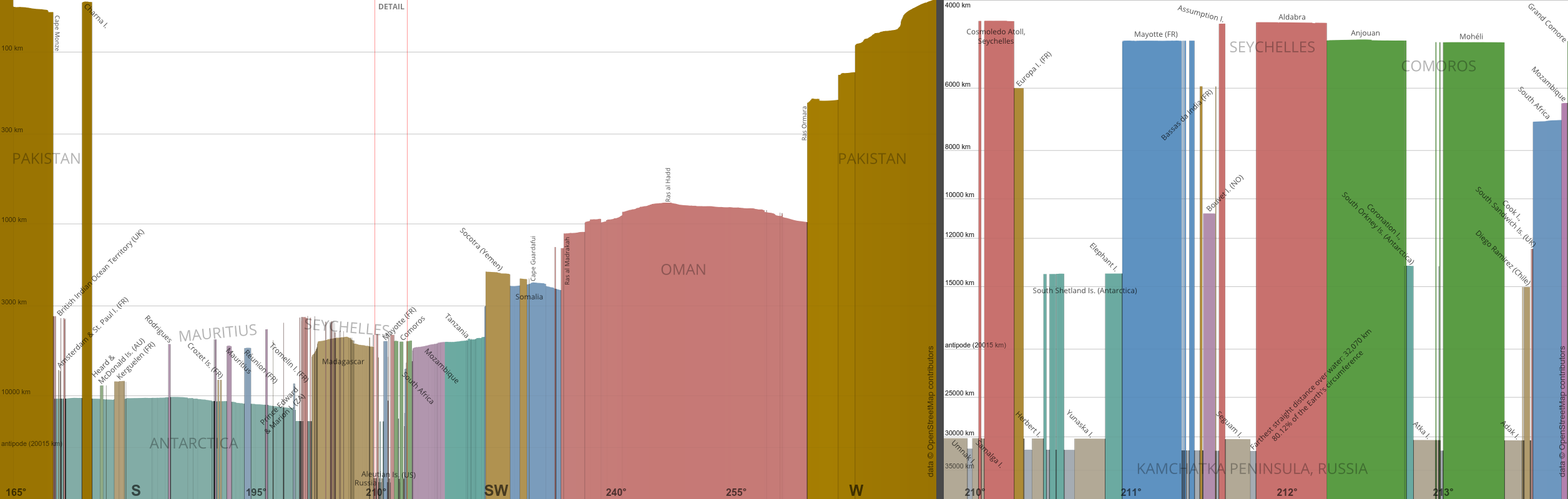
I made a "first person" perspective rendering of this: https://mrgris.com/img/landfall/longest.png
mdritch 14 hours ago
It reminds me of a bit I did a few years ago trying to find the "longest straightest" line in Atlanta [PDF]: https://matthewritch.com/pages/LongestStraightestLine.pdf
gcanyon 14 hours ago
I know the globe is unintuitive (it still blows my mind that Muslims in New York City face roughly northeast to point toward Mecca) but it still seems bizarre that the water route can start near the arctic circle, cross the Pacific ocean, nearly touch Antarctica, cross the Atlantic ocean, and cross the Indian ocean to end well north of the equator and still travel only 80% of the way around the globe. This view of the rest of that great circle helped me visualize it: http://www.gcmap.com/mapui?P=58%B037%27N+162%B014%27E-25%B01...
SamBam 7 hours ago
If you're in New York and you look due East across the Atlantic, what country are you looking at?
Most people would assume Portugal.
Nope, you're looking (over the curve of the earth, of course), at Morocco. Look just a tiny bit to the south and you're looking at the rest of West Africa. Look Southwest and you're looking at Australia, or even Brazil.
globular-toast 7 hours ago
> it still blows my mind that Muslims in New York City face roughly northeast to point toward Mecca
It never occurred to me they would face the shortest distance to Mecca. I've looked it up and apparently it's a point of contention in North America, although the great circle seems to be standard. Interestingly there are landmasses around the antipode of Mecca, which means your direction would vary wildly as you travel around.
pavel_lishin 5 hours ago
I like the idea of there being a place on land where a Muslim can look anywhere, and be looking toward Mecca.
But apparently, it's the middle of the ocean, although there does appear to be an atoll very close by: https://en.wikipedia.org/wiki/Tematagi
shrx 19 hours ago
> Figure 9: Longest Drivable Straight Line Path on Earth.
Walkable, maybe, but definitely not drivable (it crosses directly over the Alps, for example).
chabska 24 minutes ago
This is mathematics, the Alps is drivable like a manifold is smooth.
mikeaskew4 16 hours ago
Presume for a moment that you don’t drive on tyres…
pbhjpbhj 18 hours ago
There might be icebergs or sandbars or rocks or volcanic activity or wars blocking the sailing route too. They seem like equivalents.
The longest mettled straight route with minimal deviation would also be an interesting exercise.
kakacik 18 hours ago
Extremely highly inprobable vs 100% there and directly impassable unless walking & doing some proper alpinism is hardly equivalent
divbzero 12 hours ago
This geographic puzzle feels like the modern day version of the Seven Bridges of Königsberg:
1313ed01 17 hours ago
But what would flat-earthers consider the longest possible paths to be? Not the ones shown in the article, presumably?
madcaptenor 16 hours ago
Over water, probably something like the entire 60th parallel south.
Over land, I think you want to start near the westernmost point of the African continent and thread the needle of the Isthmus of Suez, and stay south of the Caspian Sea. At least in the projection gcmap.com uses (plate carree - essentially the x-coordinate and y-coordinate are just raw longitude and latitude), this keeps you south of Lake Baikal and allows you to get very far east in far eastern Russia. Something like 17.5 N, 16 W to 69 N, 178.5 E seems to work:
http://www.gcmap.com/mapui?P=17.5n16w-21.79n0.21e-26.08n16.4...
Of course this depends on the projection you use!
This is different from the Portugal-to-China path that is the longest over land in reality, which a flat-earther would have crossing the Mediterranean.
Anduia 14 hours ago
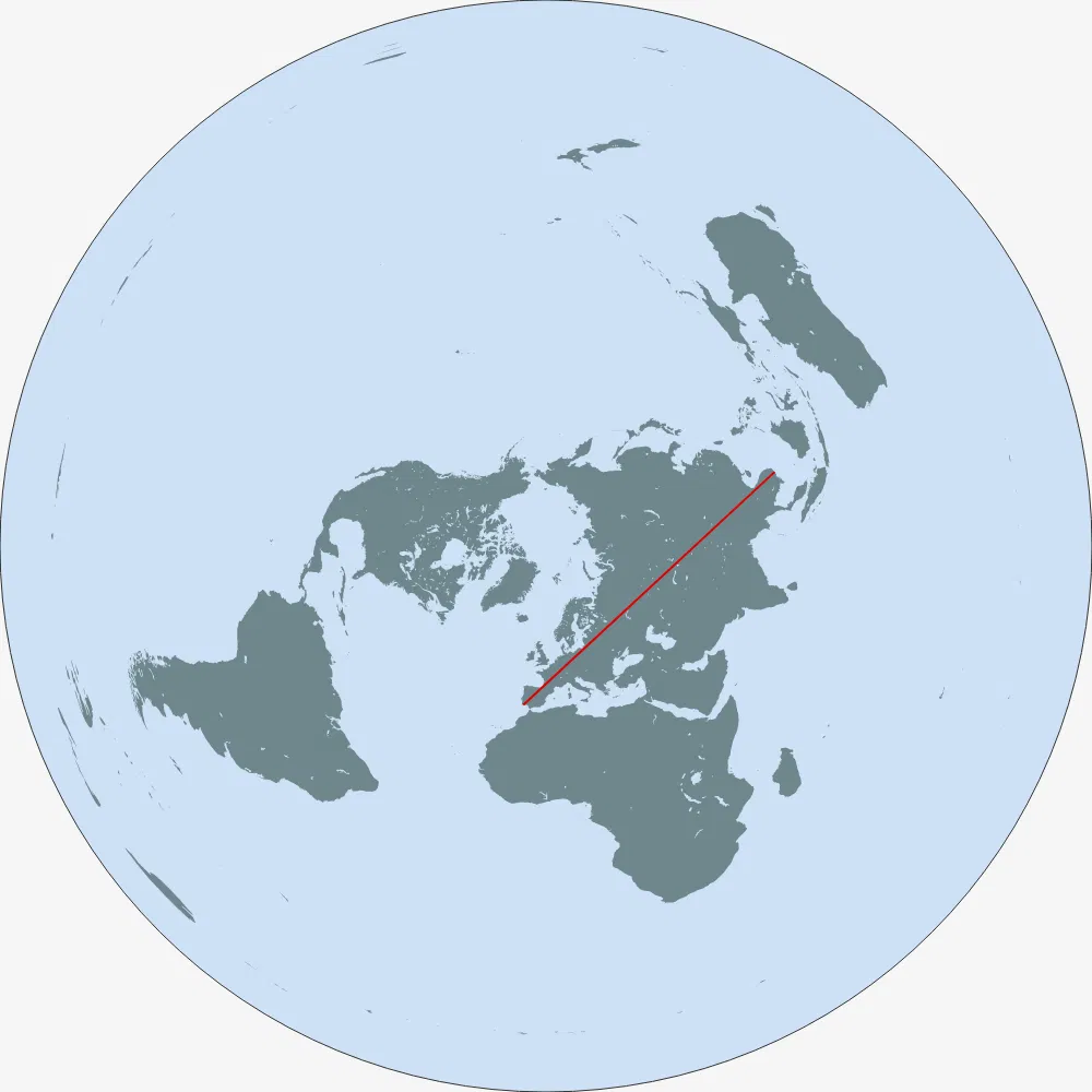
Flat earthers don't use Mercator projection, they use polar azimuthal equidistant (AEQD) projection centered in the north pole.
I think it would be something like Portugal-Kamchatka:
madcaptenor 14 hours ago
1718627440 14 hours ago
> Of course this depends on the projection you use!
But if you do not believe in a globe how do you understand projections?
madcaptenor 12 hours ago
astrobe_ 13 hours ago
They would tell us we are contradicting ourselves because none of them are straight lines in the traditional sense, if we really believe the Earth is a sphere. Don't underestimate trolls ;-)
Anduia 14 hours ago
It would be a straight line (in their official map) from the south of Portugal to Kamchatka (east Russia)
rotringlvr 15 hours ago
Before I opened the solution, I knew it had to pass through the beagle straight. It is the only choke point separating the largest oceans, about both their empties areas, the far south.
I guess my biggest surprise is that there is a straight line through the Beagle straight.
gus_massa 13 hours ago
Beagle Channel is very narrow and has islands both on the north and the south. This path goes thought the Drake Passage that is south of the islands that are south of the Beagle Channel. The Drake Passage is very wide.
rotringlvr 11 hours ago
Right, the Drake.
dr_dshiv 18 hours ago
If it is undrivable in a straight line, why does that count? I’d assume the longest you could drive in a perfectly straight line would either be the longest straight highway or some drivable desert.
loloquwowndueo 14 hours ago
“Drive”.
Use your feet, car centric person.
hnx0rqy49u 13 hours ago
Learned this the expensive way
trencedamp 14 hours ago
If it's the longest straight path on water OR land then surely it's just the circumference of the earth
paufernandez 18 hours ago
Nerd sniping at its best... ;)
metalman 18 hours ago
it would be interesting if it was a list of actual journeys with the sub lists of deviations required. a special club for the brutaly determined and persistant the "strait liners" things like having to beg, bluff, bribe, your way through someones house
shrx 17 hours ago
Wikipedia has an article listing some of the notable (walking) straight line missions: https://en.wikipedia.org/wiki/Straight_line_mission
edit: and the article already notes this longest possible path from Portugal to China, citing a 2023 article: https://bigthink.com/strange-maps/these-are-the-worlds-longe...
fhars 16 hours ago
Note that the 2023 article also cites the submission, which is five years older.
joebig 15 hours ago
I myself walked the longest path to 1200 karma. It was painful. Blisters of delta_karma=f*vote_points, where f could be 0.5 or 0.3 or unknown lower no. I'm tired, boss.